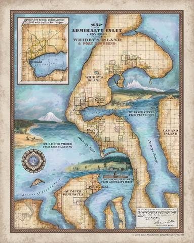
181-Map of Admiralty Inlet and Environs, including Whidby's Island and Port Townsend, Antique Map Print
Product ID: 33750884
Today Whidbey Island and Port Townsend in Washington are among the state's best heritage destinations.Port Townsend,was the Port of Entry into the United States in the 1850s; Whidbey's Coupeville was the powerful county seat of then-enormous Island County.Their founders' dreams of becoming a western metropolis led them to set their roots on the flanks of Admiralty Inlet -the gateway to the deep,protected waters of the finest commercial waterway in the Northwest This map is compiled from multiple government U.S. Coast Survey maps produced between 1856 and 1863. The original 1850s watercolors represented here are the earliest illustrations by Europeans of the region. Those of Penn Cove and Ebey's Landing were created by USCS expedition artist John Mix Stanley; an artist named Galt sketched Port Townsend in 1855. The original government maps delineated only the geometric outlines of American settlers' claims,taken under the 1850-1855 Oregon Donation Land Law.However,this enhanced map,shows not just the patterns of American settlement, but also the location of the three largest permanent Skagit villages on Penn Cove. When the Point Elliott Treaty was signed in 1855, transferring legal ownership of the region from native inhabitants to the U.S. government, displaced native people from multiple tribes throughout the region poured into the Penn Cove Special Indian Agency, located at the western end of Penn Cove (see inset). Here they awaited Congressional ratification of the treaties and relocation to permanent reservations. Swelling at its height to nearly 3,000 natives, the Indian Agency existed on the beaches alongside roughly 100 white settlers through the 1850s and into the early 1860s. Central Whidbey Island is home to Ebey's Landing National Historical Reserve, established to protect the cultural landscape and historic narrative of this beautiful region.
Trustpilot
4 days ago
1 day ago