

Grand Canyon Trail Map 5th Edition
G**L
Beautiful, unmatched - but North Rim beware
There's no map out there like this one. It's outstanding.My issue with it is formatting. It's divided front and back at an inconvenient place - between Shoshone and Grandview Points on Desert View Drive on the South Rim.The division of the North Rim is worse - Cape Royal and Bright Angel Point are on different sides, and Point Imperial doesn't even appear on the map.This shouldn't stop you from getting this map. The way it's colored makes it easier to understand all the geological features you see from the rims. That's mainly what I use it for.If you're going to the North Rim, you'll need the National Geographic Arizona Grand Canyon North and South Rims map, which had Point Imperial and the main North Rim points on the same side of the map.No problem, though. Can you really have enough Grand Canyon maps? :-)
A**L
An AZ Hiker's Favorite Map for Grand Canyon
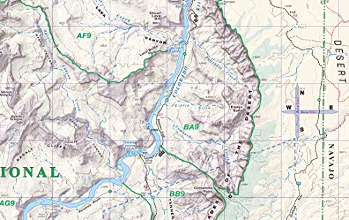
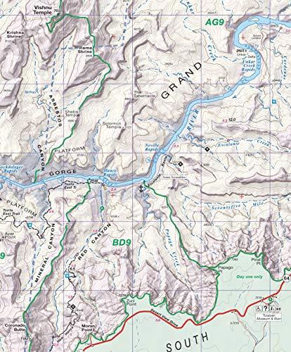
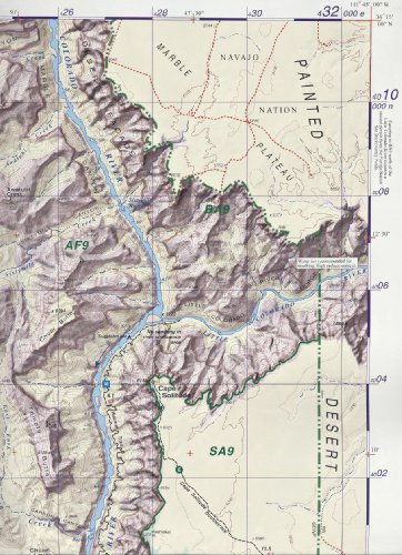
It's all been said by other reviewers. I'll simply add that I find this map FAR and AWAY easier to read than the Trails Illustrated maps. If your eyes, like mine, are over 50 years old, you may, too. It covers the core of Grand Canyon National Park, at a great scale. Just be sure you review the information about what this map covers, if you're thinking about hiking in an extremely remote part of the Canyon (particularly in parts more than a few miles west of Hermit's Rest). The images provided by Amazon at the top include an image that shows the area covered by this map, compared to the 7.5 minute quads. In addition to the map, this document provides brief descriptions of all the trails (both maintained and unmaintained) so you could use this and not need a separate guidebook.
S**L
I really like these maps
I really like these maps. This covers the majority of the Grand Canyon trail system and this is the map that the park ranger told me he prefers to see visitors have on hand. Very durable. Most importantly, very accurate. I used Sky Terrain maps last summer in the Aspen/Crested Butte area and was highly impressed. My experience with the GC map did nothing but reinforce that opinion. I think they set the standard in topographic maps. If you plan on doing any backpacking in the GC, this is the one to buy. The maps they give you at the park entrance only cover the amenities and roads at the rim and maps of the park shuttle. This has all the backcountry zones and sites, as well as the more established sites well marked. Great for trip planning too. One side covers the rim/slightly western side of the park while the other side covers the eastern aspects of the park. I purchased it for its full coverage of the Escalante and Tonto trail.
M**S
Best map for Backpackers
This is definitely the best map for backpacking. That being said, it is only as good as the information provided to the map makers.It rates the trail or trail section by difficulty which is extremely useful in trip planning.The water sources are listed on each trail. This is incredibly useful.The contour lines are easy to find and count. The important features are labeled.The map is very durable. It's water resistant and tear resistant. It's not idiot proof. When they build a better map, someone builds a better idiot.
D**S
I like this better
I started my hikes with the National Geographic map set. That's a good set, but after looking at the Sky Terrain set, I'll take this next time. It includes more detail, particularly if you want to get a little away from the regular routes. For example, the NG set doesn't give you much if you head west from the Hermit's Rest Dripping Spring Trail junction. We hiked a few miles in there, relying a cell phone app. I would have done at least twice the distance and time if I'd had a paper map. Only after we'd finished our latest series of day hikes did we find the Sky Terrain maps which included these areas. Next time I'm there, I'll be using a Sky Terrain map.
Trustpilot
1 day ago
1 week ago